

30 July 2025 Indian Express Editorial
What to Read in Indian Express Editorial( Topic and Syllabus wise)
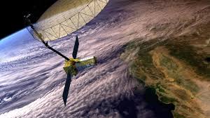
EDITORIAL 1: NISAR’s two eyes on Earth
Introduction
Earth observation satellites are fairly common these days, with countries routinely deploying them in space for a variety of purposes.
NISAR
- It is the first time that ISRO and its US counterpart, NASA (National Aeronautics and Space Administration), have jointly built a satellite, which is why it has got the name NISAR (NASA-ISRO Synthetic Aperture Radar).
- NISAR is special for several other reasons. Once deployed, it will be the most powerful Earth observation satellite in space,producing data and high-resolution images that will facilitate research in a variety of fields.
- It is the first satellite to be mounted with two Synthetic Aperture Radars (SARs), operating in different frequency bands, a technological feat that has made it immensely powerful and useful. It also happens to be the most expensive satellite ever.
Double SARs
- NISAR’s uniqueness is the two SARs that it is fitted with. Radars — the familiar large dish-shaped antennas— are instruments that send out signals in the non-visible spectrum of electromagnetic waves, typically microwaves or radio waves, and collect the signals that bounce back from objects.
- The returning signals are then analysed to glean a variety of information about the object, like its distance from the radar, its velocity if it is moving, and composition, texture or other properties of the object.
- In general, the larger the size of the dish antenna, the greater the amount of information collected from returning signals. Imaging radars use the returning signals to create an image of the object.
- SARs are a special kind of imaging radar that are deployed in space where large dish-like radars, similar to those installed on the ground, cannot be sent.
- SARs make up for this limitation with sophisticated technologies and algorithms to mimic the power and resolution of large ground-based radars.
- NISAR’s antenna of 12-metre diameter, for example, is capable of producing images whose resolution would be comparable to those produced by a simple ground-based antenna 20 km in diameter, according to information put out by NASA.
- A number of SAR-mounted satellites are currently deployed in space. ISRO’sRISAT (Radar Imaging Satellites) series of satellites, which have now been renamed to the EOS series, carry SAR.
- Some of ISRO’s other Earth observation satellites, like Cartosat or Oceansat, do not use SAR.
Unprecedented imagery
- The power of NISAR comes from two SARs, one operating in the L-band frequency and the other in the S-band.
- Both the L-band and S-band radars can see through clouds, smoke, rain or fog, thus getting an unfiltered view of the Earthacross all weathers and through day and night.
- Their different wavelengths then enable them to capture different kinds of details on the surface.
- The L-band SAR, which uses higher wavelength microwaves, can better penetrate tree cover or vegetation, and even sand or ice. It is, therefore, able to capture minute details of surface undulations, and can see through dense forest cover, for example, to map the ground below and measure tree trunk biomass, which is very useful for estimating carbon stock.
- The S-band SAR, which has a shorter wavelength, is unable to go much deeper, but is good for capturing the larger features, such as crop fields or water bodies.
- It can observe crops like soybean, corn, sugarcane and provide information on their different growth and maturity stages. This observation will especially focus on India.
- On NISAR, the two SARs are designed to work synchronously and complement each other.
India-US collaboration
- The L-band SAR, the 12-metre antenna, and many other components and systems, including GPS control, have come from NASA, while ISRO has contributed the S-band SAR, the rocket and spacecraft and its sub-systems, and will carry out the launch.
- Both NASA and ISRO will handle the mission operations from their respective ground stations.
- The concept for a NISAR-like mission emerged in 2007 when a US committee had recommended a space mission to study how changes in land, ice or vegetation cover were taking place.
- India has signed on to the Artemis Accords, a sort of US-led alliance on space exploration that is closely linked to NASA’s Artemis programme seeking a return of humans to the Moon.
Conclusion
NASA and ISRO have also worked out a strategic framework for human spaceflight cooperation, one of the first outcomes of which was the participation of Shubhansu Shukla in the NASA-facilitated Axiom-4 private mission to the International Space Station.
EDITORIAL 2: Where and how flash floods are impacting India
Context
More than 100 people dead in Himachal Pradesh, at-least 373 killed in Kerala’s Wayanad, five soldiers lost their lives in Ladakh and dozens dead in Sikkim.
One common trigger
- Although these events took place in different parts of the country, they had one common trigger: flash floods.
- Every year, more than 5,000 people die, and significant damage is sustained by infrastructure, agricultural land, and the environment due to these sudden floods,which are caused by extreme rainfall.
- To make matters worse, with rising global temperatures, there has been an increase in the frequency of flash floods.
- For instance, between 2020 and 2022, the number of flash flood events increased from 132 to 184, according to the Union Ministry of Jal Shakti.
The challenge
- Despite the increasing threat posed by flash floods, there has been insufficient research to identify areas that are most vulnerable to this extreme weather event.
- This has posed a challenge in implementing adaptation strategies such as early warning systems.
- A new study by researchers based at the Indian Institute of Technology (IIT)- Gandhinagar has tried to address this gap.
- They found flash floods are mainly centred in the Himalayas, the west coast, and Central India.
- It has also revealed that several regions in the country have become more vulnerable to flash floods than before, due to soaring temperatures.
Driving factors of flash floods
- According to the study, only 25% of the flash floods that occur in India are directly caused by extreme precipitation. The rest of them are a result of a combination of extreme rainfall and the condition of the soil before precipitation.
- If the ground is already wet before a heavy rainfall event, chances are the soil would be saturated or near saturated, which can lead to instant runoff. This increases the risk of flash floods.
- The study also notes that an extreme rainfall event leads to immediate flash floods only 23% of the time. Usually, it is the prolonged low-intensity and high-intensity rainfall which results in these floods.
- At the most vulnerable regions, other factors also contribute to flash flood events. For instance, in the west coast and Central India, flash floods are driven by the high flashiness of sub-basins (part of large river basins).
- This means that their water levels quickly reach the peak after a heavy rainfall event. Prevailing soil conditions play a crucial role in how rapidly water infiltrates a sub-basin.
- In the Himalayas, geomorphological factors — such as steep slopes, and high relief contribute to flash floods.
- Flash flood susceptibility varies widely within the major river basins. For instance, the sub-basins located in the Himalayan regions and the southern parts of the Ganga River basin are highly prone to flash floods, whereas the sub-basins in the central regions of the Ganga River basin exhibit low flash flood susceptibility.
- This variation in flash flood susceptibility underscores the influence of terrain and climatic factors on flood risk within different parts of the same river basin.
Role of climate change
- With rising global temperatures, extreme weather events such as flash floods are increasing in frequency and intensity across the world.
- That is because for every 1 degree Celsius rise in average temperature, the atmosphere can hold about 7% more moisture, leading to more intense precipitation, which exacerbates the risk of flash floods.
- In India, between 1981 and 2020, the yearly frequency of extreme precipitation events doubled during the pre-monsoon season.
- Extreme rainfall during the monsoon, post-monsoon, and winter seasons has increased by 56%, 40%, and 12.5% respectively, according to the study.
- There has been a notable increase in flash flood events since 1995, with most of them occurring in the Brahmaputra River basin, followed by the Ganga and Krishna River basins, the study said.
- Rising high temperatures are leading to more wet hours in most of the sub-basins, which are not currently flash flood-prone.
- Across all the Indian river basins, 51% and 66.5% of the non-flash flood-prone sub-basins show an increase in precipitation and streamflow, respectively.
Way forward
- The findings indicate that authorities need to adopt region-specific adaptation strategies, which are based on factors such as topography and soil conditions, and not just extreme rainfall events.
- This can help in developing better early warning systems, targeted disaster preparedness, and long-term adaptation plans, according to the researchers.
- Authorities also need to identify new potential flash flood hotspots and take measures like building climate-resilient infrastructure to limit the impact of the extreme weather event.
![]()